
National Geographic: British Isles 1958 - Historic Wall Map Series - 19 x 25 inches - Laminated
Product details
| Management number | 211999100 | Release Date | 2026/04/06 | List Price | $36.00 | Model Number | 211999100 | ||
|---|---|---|---|---|---|---|---|---|---|
| Category | |||||||||
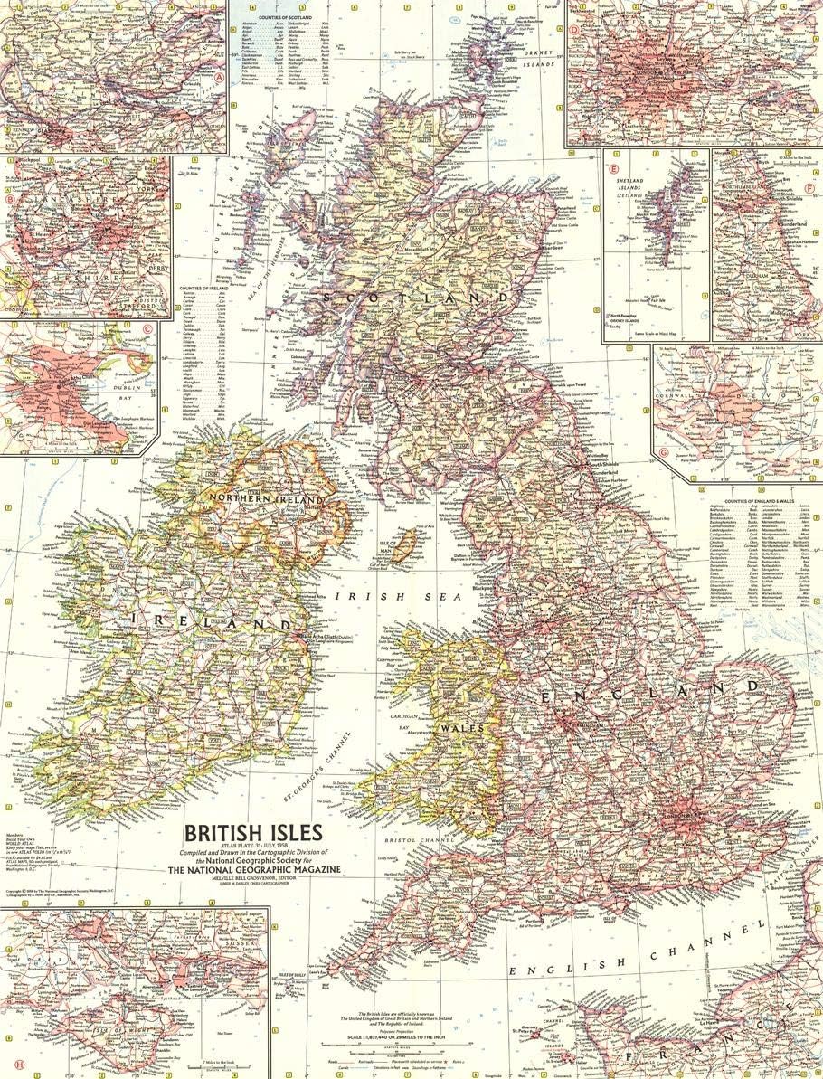
"If 17th century cartographer Speed could see the National Geographic Society's new British Isles map, he would find place names already old in his time mingling with others attuned to today's Age of Discovery." Published in July 1958, this map of the British Isles accompanied the article "New Atlas Map Links Roman and Atomic Times in the British Isles."This map, featuring National Geographic's legendary mid-century cartography, is one of the past and the future. Hadrian's Wall, built in the second century on Hadrian's wish to keep the Roman Empire intact against invading barbarians, contrasts with the Jodrell Bank Observatory, established in 1945 at the end of the Second World War. Hastings, where William the Conqueror triumphed in 1066, looks across the English Channel - and nine centuries - to the beach battlegrounds of WWII.Insets of London, Manchester & Liverpool, Edinburgh and Dublin (Baile Átha Cliathe) show the massive expansion of modern cities as they marched on with technological innovations. One of Plymouth, from which the ship The Mayflower disembarked on its mission to deliver the Puritans to the North American coast, shows that it, too, has grown.This map is drawn in a Polyconic projection, where the parallels are all non-concentric circular arcs.A perfect addition to any collection, this mid-century cartographic work is a fine companion for the artistic British Isles map published in 1949.Your laminated map has a glossy finish so that you can use dry erase markers on the map to highlight features, make plans, and share unique information with others. Lamination is also extremely durable, resistant to folding or ripping.Your map is rolled and packaged in a sturdy tube to protect it during shipment.
- CLASSY MAP IN OFFICE OR HOME: You can't go wrong with this beautiful production from National Geographic. A guaranteed conversation piece!
- A MUST-HAVE FOR COLLECTORS: This map beautifully depicts Great Britain's growth after the devastating WWII.
- USE WITH DRY ERASE: Highlight areas on the map and wipe off when you're done on this glossy laminate finish
- DURABLE MATERIAL: With laminated product, your map is protected from tears, folds and liquids
- ICONIC CARTOGRAPHY: National Geographic's maps are the standard others are measured against. You can count on this product having the highest quality content and display in the industry.
| UPC | 749717014909 |
|---|---|
| Map Type | World |
| Brand Name | National Geographic |
| Paper Size | 19 x 24.75 Inches |
| Manufacturer | MapSherpa |
| Paper Finish | Glossy |
| Item Dimensions L x W | 25"L x 19"W |
Bestseller ranking
Regulator Inlet Nuts


Customers who viewed this product also viewed
Maps


Correction of product information
If you notice any omissions or errors in the product information on this page, please use the correction request form below.
Correction Request Form